Tuesday, September 22, 2009

Unfinished DC Business - Ft. Stevens

In July of 1864, the Army of the Potomac was applying considerable pressure on the defenses around Richmond.  Confederate General Robert E. Lee detached his Second Corps, under the command of General Jubal Early, to reclaim the Shenandoah Valley, a vital food source for the Confederates, and, if possible, invade Maryland from there.  All of this would be done in the hope that the mere presence of the Second Corps in the area would pose a threat to Washington, DC, and force Union commander Ulysses S. Grant to recall some of the troops around Richmond in order to protect his own capitol.

Early won an engagement at Lynchburg, Virginia, and then another at Monocacy, Maryland.  At noon on July 11, his troops arrived just outside of Silver Spring, Maryland, and began scouting the Union positions.

They ran into the northern portion of the ring of forts that protected Washington, DC.  More specifically, they ran into Ft. Stevens.  (A complete account of the battle can be found HERE).


 I mention all of this because, one day, as I drove down Georgia Avenue - the most direct way into the city from where I lived - I saw a sign: Ft. Stevens.  I turned left and drove up the hill.

(Photo courtesy of the Library of Congress)

As it turns out, Ft. Stevens is important for three reasons.  1)  A portion of it still exists.  2) The battle there was really the only significant time that the ring of defenses around Washington, DC was tested (Early decided the defenses were too strong for his force, and withdrew, but he had accomplished his chief aim.  To bolster the Union defenses, Grant had sent his VI Corps and XIX Corps from the outskirts of Richmond).  And 3), President Lincoln himself rode out to watch the battle develop, since it was just a few miles north of the White House.  As he stood on the earthen ramparts, a Union surgeon nearby was hit by sniper fire.  Officers scurried to get the President under cover, but it was one of only two times that a U.S. president has come under enemy fire while in office (the other being President Madison's brief escapade during the Battle of Bladensburg (Maryland) during the War of 1812).

The restored part of the fort now looks like this:

The rock monument that is somewhat visible behind the far cannon in the picture below allegedly marks the spot where Lincoln stood as he observed Confederate forces maneuvering for position.


The fort was a terrific way to start a Sunday drive into the city, and it was my introduction to the the Civil War Defenses of Washington

In Washington, DC, it doesn't take long to realize that, throughout the capitol's relatively short history, there have always been planners and thinkers who wanted the city to be a grand symbol of the world's greatest democratic experiment. 

After the Civil War, the city's defenses were abandoned and fell into disrepair.  But, in 1902, instead of selling off the many strips of land for private development, a special congressional committee, with unusual foresight, recommended keeping the derelict earthworks and half-buried trenches and converting them into lands reserved for public use.

Thus was born the substantial ring of green space around the city that is sometimes known as the Fort Circle Parks.

From the National Park Service website:

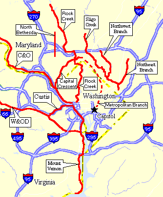
On forested hills surrounding the nation’s capital are the remnants of a complex system of Civil War fortifications. Built by Union forces, these strategic buttresses transformed the young capital into one of the world's most fortified cities. These forts remain as windows into the past in the midst of D.C.’s urban green space, offering recreational, cultural, and natural experiences.
From the original circle of fortifications, nineteen parks remain (in red on the map below) and are administered by the National Park Service.


Tuesday, September 8, 2009

The Sea...

Once it was apparent that I would have to leave DC and head back to Florida, I became impatient. I missed the people and places that had been familiar to me for so many years, and I felt that staying for the remaining days on my lease would be time and money wasted. As much as I liked the DC area, and had explored it and gotten familiar with it, I sometimes felt like a guest who had lingered a bit too long.

During the last full weekend in August, I decided to do some preliminary organizing in the hope of making an orderly departure. I cleaned. I threw things away. I packed. Before I knew it, the only task remaining was to load up the Raft (my car) and go. On Sunday, August 23, I was done. I decided not to wait. At 4:15 in the afternoon I drove down Layhill Road to Georgia Ave, and, from there, turned on to the ramp for the Beltway (I-495) which would take me to I-95. I thought I would drive as far as I could go. If I got tired, I'd stop. If not, I'd continue on.

As it turned out, I stayed as alert as could be expected on a thirteen hour, eight hundred mile drive, and, somewhere along the way, had a great idea; I would continue past the turn-off that would take me to Gainesville, stay on I-95 until I reached St. Augustine, and arrive in time to watch the sun rise on St. Augustine Beach.

There was one thing I hadn't counted on when I settled in DC for the summer - I missed the beach.

In retrospect, I shouldn't be surprised. Many of my favorite childhood memories come from the considerable amount of time I spent at my grandparents' summer home on the South Shore of Massachusetts. Life revolved around the beach, the marina, the town pier and the harbor (pronounced hah-buh). Even after moving away from there, I lived in a coastal town in South Florida before shipping off to Gainesville for college.

Toward the end of my stay in DC, despite all the fantastic things there are to do, I began to crave the sand and the sea. Ocean City, Maryland was 160 miles away, and I'm told it would disappoint those accustomed to Florida beaches. Virginia Beach was well over 200 miles away; not a distance meant for day trips.

So it was that, at 5:04 on the morning of August 24, I crossed the bridge to St. Augustine Beach, anxious for a cup of coffee, an ocean breeze, and the sound of the rolling surf.

The sea has always felt like home to me, even during the times I've been away from it, and I'm surprised now that I never considered that fact before I decided to make a move. I snapped a picture with my phone camera; it was the only suitable device I could pry out of my packed car. The beauty of the image - even on a lousy camera - tells you how fantastic the sunrise was.


I had breakfast at the Beachcomber, propped my lounge chair on the beach, and fell asleep. I wasn't back in Gainesville yet. But I was home.

Friday, August 21, 2009

Stained Glass and Good-Byes...

The weather today was lousy. Angry clouds and drenching rain all day. It was the perfect opportunity to clean up and start packing. I am anxious now to be back in Florida, to see family and friends, to enjoy familiar surroundings, to move on.

My experience in Maryland has been extremely stressful, partly due to events beyond my control, but largely because of circumstances I created for myself. I realize now that it was more about time than place. I moved to the Washington, DC suburbs because I genuinely like the area, and the city itself, but what I really needed was time to enjoy the things I like about myself, and time to examine the things I don't like. What do you do when you discover that the person you have become is not the person you want to be?

There is no easy way to change direction when you have been in the same town, working the same job for years and years. I wanted to break all routines of behavior, disrupt all patterns of thought, and keep the strongest parts of the old life structure while adding to it new features that will make it more durable, and more functional.

The process is nowhere near complete. I'm only now beginning to understand that the New Clothing Enterprise will last as long as I do. But I've noticed differences in myself. And I like them.

I find that waves of warmth flow over me when I see loving parents cuddling a happy toddler. I eat slowly, and enjoy my food. I sip drinks. I stop when I see flowers or trees or patches of blue sky that remind me how great it is to be alive. I will literally stand and smile, and enjoy the sight, and let it register in my mind. If you can't find happiness in such things, where will you find it? Never surrender your right to live in the moment. Who knows how many moments we have left?

I no longer get upset when I make wrong turns, especially if it's a road I've never been down before. How many wonderful things and places have been discovered by accident? I talk to animals now. Not far from where I live, there are two areas that always attract deer at dusk. When I walk past them as I return from the train station at the end of the day, I have made it a habit to say, "Hi deer," and then chuckle to myself. You should try it. It works. Don't worry, the animals haven't started talking back. Yet.

After doing some preliminary packing, I went up the road to the Stained Glass Pub. It's the nearest place to get a drink and watch sports with a boisterous crowd of regular patrons. I went there often when I first arrived here. People were immediately tolerant, if not downright friendly. I had chatted with a handful of them. I had gone four weeks without a visit there, four weeks without any alcohol at all, actually, and I think they missed me. Now I had to say good-bye.

Before I left the house, Jun Li, the young Asian guy who lives across the hall, was stocking the fridge with a 12 pack of Heineken. He always has beer. I asked if the box of wine that had been chilling in there for weeks belonged to Cynthia, and tried not to make a face at the mere thought of wine in a cardboard container. No, the wine was his, he said, in case of emergencies. I laughed and wondered what would constitute an "emergency."

After I shuffled through a slight drizzle from the car into the Pub, I hadn't been at the bar for more than twenty seconds before Murat slid a cold mug of Stella in my direction. He's good about that.

Hunter stopped to chat. He is a crusty old guy who manages the kitchen during the week, but works weekend shifts as a server for extra money. His throat is ravaged from years of smoking and drinking, but he is a character. It is karaoke night in the other room, and he sees me wince as someone hits a sour note. Karaoke originated in Japan, and I wish it had stayed there. Seeing the expression of painful disapproval on my face, Hunter leans in to my ear and whispers, "Next to the CIA and a handful of others, I'm one of the few who knows that karaoke is covert, long-term payback for Hiroshima and Nagasaki."

He walks off to one of his tables, and then looks back. His eyes sparkle in the dark room when he turns to see me still laughing. He looks tired, but I know he is enjoying himself.

Another man, whose name I can't remember, walks by. He's wearing a T-shirt that tells you everything you need to know about him. It says: No sense in being pessimistic. It wouldn't work anyway.

I stayed for three beers and the end of the Redskins game, then I was ready to go. I thanked Murat for his kindness, smiled and waved at a few others, and left.

Next stop: Florida.

The New Clothing Enterprise continues...

Wednesday, August 19, 2009

Escape...

I was so taken by the setting of Ft. Washington that I decided to return there, but I felt like I needed another excuse to justify retracing some of my steps. So I decided I would search for the first two stops on the escape route of John Wilkes Booth.

The Booth Escape Route (you may need to click the photo and view the enlarged version)

Most of us know the story (if the details are sketchy in your mind, you can find information on Lincoln's assassination HERE]. On April 14, 1865, Booth, acting somewhat in conjunction with a handful of others, shot the president, and fled across the Navy Yard bridge into Maryland. He stopped, initially at a home owned by Mary Surratt in Clinton, Maryland.

This modest plantation home had done a variety of duties. The Surratt's ran it as a tavern, boarding house and post office. John Surratt, Sr died in 1862, leaving behind considerable financial difficulties, and Mary rented the home to - oddly enough - a policeman, and moved into Washington, DC to run a boarding house. It was there that she and her son, John, Jr, met John Wilkes Booth.

As Booth fled the capitol on the night of the assassination, he met up with co-conspirator David Herold, and stopped at the Surratt house to retrieve weapons and supplies that had been stashed there.

The Surratt House

I will add one interesting side note; according to the Surratt Society website [Link HERE], Mary Surratt - as a result of whatever role she played in the whole affair - became the first woman executed by the United States government.

Of course, as we now know, Booth had broken his leg while jumping from the president's box seats to the stage below. He and Herold went to visit Dr. Samuel Mudd, where they spent the night.

The Mudd House

The house still belongs to the Mudd family, and has limited visiting hours.

I could have continued south from the Mudd House, following the rest of the Escape Route to the edge of the Potomac, where Booth eventually paddled across to Virginia, and then was trapped and killed by Union soldiers, but I had gone far enough for one day. It was time for my own escape, and the reason I ventured back into this area in the first place.

I drove to Ft. Washington. After all, it was a Fee Free Weekend! I wanted to sit and relax as the day came to an end, and really enjoy the beauty of the place. This time, I brought fresh whole wheat bread, cheese, grapes, and organic iced tea with spearmint. And I had picked out the perfect picnic spot the day before...

Monday, August 17, 2009

Forts (Part 2)...

Here's a test. Name a battle from the War of 1812. It's okay. Take your time.

Give up? Most people will eventually remember the Battle of New Orleans (probably because of that stupid song), and, if you think long enough, you might come up with Ft. McHenry, since it led to the birth of our national anthem. Beyond that, the war is largely a black hole in American history. When the enemy captures and burns your capitol, it's not likely to be remembered fondly.

The British, you see, were fighting the French. I know, when were they not fighting the French? (Answer: When they were fighting the Spanish!) The king (possibly still bitter about the whole revolution thing) was mad that the former colonies were continuing to trade with the French despite the fact that the former mother country was at war with them. The Americans, it seems, had become rather fond of champagne, perfume and fancy underwear. The tension eventually caused an outbreak of hostilities in 1812, although the British weren't terribly interested until 1814, since, by then, they had finally defeated Napoleon, and banished him to the island of Elba.

I mention this because the War of 1812 was the first time that the site of Ft. Washington came into play, and Ft. Washington was the next fort I visited after Ft. Foote.

[National Park Service site HERE]
[Google aerial view HERE]

Ft. Washington was originally called Ft. Warburton. It was a very simple structure, completed in 1808 to protect the Potomac River approaches to the cities of Alexandria, Virginia and Washington, DC. When, on August 19, 1814, British forces landed at Benedict, Maryland on the Patuxent River, and began moving toward Washington, DC from the southeast, the fort's commander, Captain Samuel Dyson, was naturally quite concerned. After winning the Battle of Bladensburg - 6 miles east of Washington, DC - on August 24, the British spent a restful night in the nation's capitol, but not before taking time to set fire to the government buildings.

On August 27, as British foot soldiers retraced their steps toward Benedict, the British fleet sailed up the Potomac and approached Ft. Warburton. Dyson had a garrison of just 49 men, and, faced with the enemy land forces behind him and the enemy fleet in front of him, he did what any sensible commander would do under the circumstances; he used his 3,000 pound store of gunpowder to blow the fort to smithereens, and then ran screaming into the night (a court martial later found him guilty of abandoning his post and destroying government property).

From there, the British turned their attention to Baltimore, were repulsed at North Point, and at Ft. McHenry, about which Francis Scott Key wrote a moving poem, and the rest, as they say, is history.

But it was from this inauspicious beginning as Ft. Warburton, that Ft. Washington was born. As early as 1794, the great general and the nation's first president had recognized the need to construct fortifications on the high bluffs at this location, partly because it offered a terrific field of fire that would discourage enemy ships from advancing up the Potomac, and partly because it was right across the river from his house.

The War of 1812 had shown the young nation that real coastal defenses, capable of actual resistance, were necessary. Where they existed, such as at Ft. McHenry, they had been successful. By 1824, Ft. Washington was completed on the site of the less fortunate previous fort, and, I have to tell you, for a visitor, Ft. Washington is fabulous.

Before I continue, I should note that, by some miracle, I had stumbled on another Fee Free Weekend at a national park, and was thus robbed of one more opportunity to use my Annual Pass.


But, as you can see, the location did not disappoint.


The purpose of the structure was simple: to contain and shelter as many weapons as possible, almost all of them pointed at the Potomac River. Coupled with Ft. Hunt on the Virginia side, this would have made a considerable gauntlet for invaders intent on sailing up to Washington, DC.


The early fort was improved in the 1840's, and again in the 1890's when eight concrete shore batteries were added to supplement the original casemate fort.


The fort was abandoned twice along the way - it was empty for nearly twenty years after the Civil War - but was reoccupied whenever foreign hostilities arose.


Finally, the site was turned over to the Department of the Interior, in 1946, right after World War II.


At some point, a small wooden lighthouse was constructed where the rugged spur of land extends furthest into the river. I wandered around for a few hours, and then found a spot on the bluff to watch the sun fall behind the distant trees. If only I'd thought to bring champagne...

Sunday, August 16, 2009

Forts...

This weekend I decided to explore forts. A string of them - literally dozens - once surrounded our nation's capitol, most of them from the Civil War, but some from before or after. I set out for Ft. Foote, on the Maryland side of the Potomac, a few miles south of DC.

[National Park Service site HERE]
[Google aerial view HERE]

It is little more than ruins of a Civil War era fort now administered by the National Park Service, and it is very much off the beaten path, but I knew as soon as I turned into the entrance that I would like it.

There, right next to the dirt road, was a mother deer and her little one, and they wouldn't get out of the way! I wanted to hop from behind the wheel and walk up and say, "Look, I'm one of those nasty human beings that you frequently see from a distance, and you should have run off in sheer terror about three minutes ago." Finally, I just drove slowly by. The grass in that particular spot must have been delicious. Mom and baby stopped chewing, and just looked at me as I passed on the way to the little parking lot. Then they resumed.


It soon became apparent why the fort was left untouched, or, more specifically, why the cannons were left untouched. Some of the guns placed here were so big it was difficult to remove them once they were no longer needed. I'm sure, at the start of the war, with Confederate troops running back and forth out there in the woods and warships sailing around God knows where, there must have been a sense of urgency to move the things into place. After the war, when someone got the bright idea to relocate them, I'm guessing the response was a series of raised eyebrows, accompanied by a "you must be joking" look. These are Rodman 15 inch smoothbore cannons. Two of them remain at the site. To get an idea of their size, you can compare them to the couple from Kansas and their young daughter that I ran into during my wanderings.

(Don't forget, you can click on each of these images to view larger versions)


These monsters fired an iron ball that weighed 434 pounds. The guns themselves weighed 49,000 pounds. I wouldn't want to move them. Would you want to move them? So, here they sit, in the Maryland woods on the edge of the Potomac, surrounded by apparently scrumptious fields and lovely trees.


The arched, concrete structures that were powder magazines, and supporting facilities have seen better days, but they are still very much in evidence. I love walking around places like this. It never ceases to fascinate me. The trick is in trying to picture yourself there at the time. Imagine you are Fred the Union Soldier, and you are standing by the front gate in 1863 wondering why the deer won't go away. Your rations haven't been up to par lately, and you're thinking about munching some of that grass yourself...

Anyway, sites like this are great because there usually isn't much to them, and you can move along quickly without feeling like you've left something out. It gives you a real feeling of accomplishment. There was one curious thing. A road led from the parking lot to the ruins, and another road led, after a half mile or so, to a grill and a trash can. I'm not kidding. Here they are, hundreds of yards way from anything else in the park:


I was trying to figure out why this would be the case, when, because I have become so adept at imagining myself in another place and another time, I pictured park headquarters during the meeting that must have decided on this arrangement.

Ranger 1: Well, we think we have the Ft. Foote park ready to open to the public, sir. Most of the debris has been removed. We've cleared a parking lot and a road to the site. We've even made sure there is no residue remaining from the gas tests that were conducted there during World War I.

Head Ranger: Excellent. (looks at a map of the site, and wonders about the other road). What is this road for?

Ranger 1: Nothing, sir.

Head Ranger: Nothing?

Ranger 1: That's correct, sir.

Head Ranger: Well, why is it there?

Ranger 1: We didn't actually want the road to be there, sir. It's just the place where they parked the bulldozer for breaks and lunches while they were clearing the road that we did want.

Head Ranger: I see. (pauses to think) That's a problem.

Ranger 1: What do you mean, sir?

Head Ranger: People will be mad if we let them walk down a long road that leads to nowhere.

Ranger 1: I see your point, sir.

Ranger 2: (meekly, unsure of himself) We could... We could put a grill at the end of the road, sir.

Head Ranger: A grill? Why on Earth would we want to put a grill at the end of a long road that leads to nowhere?

Ranger 2: That way, when people get to the end of the road, they would think that the road was there to take them to the grill, sir.

Head Ranger: (thinks again, for a long moment, then exclaims) By God, that's genius!

Ranger 2: Thank you, sir. (bolder now) We could even put a trash can with the grill, sir. That way it would really appear as if we intended them to be there all along.

Head Ranger: (excited now) Genius, I tell you. Genius. (looks at Ranger 1) What do you think about that Ranger 1?

Ranger 1: Installing a grill and a trash can would be much cheaper than erasing a long road to nowhere, sir.

Head Ranger: (pounds the conference table decisively with a clenched fist) Make it so.

I inspected the grill, and it looked as if it had actually been used at some point, although probably not since the Carter administration. But Ft. Foote was a great way to start the day, and a perfect primer for what was to follow...

Tuesday, August 11, 2009

Moving Up...

Yesterday, I spent most of the day moving my stuff to one of the upstairs bedrooms. Rachel and Leslie moved out over the weekend, and Lisa (the landlord) wanted to embark on a massive re-organizing effort downstairs, and then advertise both of those rooms for rent since they seem to be more desirable. It appears that I will only be in the house for a couple more weeks, and, with two rooms coming open, I had volunteered to move anywhere that made things easier for Lisa. So, after some cleaning and preparation, I moved to Rachel’s old room on the second floor, up two flights of stairs from the basement.

In some strange way, I was looking forward to it. I wanted to see what life was like up there in the lofty heights. Despite the common area that opened to the back deck, the downstairs room felt like a cave, quiet and secure, but also dark and isolated. Usually, I enjoyed the solitude, but sometimes I felt like an inmate on Alcatraz.

Immediately after settling in the new room, I noticed some differences.

As you know, hot air rises, therefore, thermostats in multi-level dwellings are tricky things. It took only a few moments before I understood why the upstairs folks were always adjusting the temperature. While you could hang meat in the lower regions of the house, the upstairs seemed a bit toasty. I soon noticed that there were ceiling fans in all the rooms, and that the temperatures were actually in the normal range, it’s just that I had become accustomed to shivering even when it was ninety-five outside. Soon, I was quite comfy.

Then, during my first trip to the upstairs bathroom, I noticed that the exhaust fan is rather old, and, for about ninety seconds after you flick the switch, it sounds like Marine One is attempting to land on the roof. But it settled into a more restrained cacophony, and, after trudging up and down two flights of stairs forty times, the hot shower was a welcome relief.

The next major change involved sleeping. The downstairs room had a normal twin bed. This room has a queen-sized air bed. I’ve never slept on one before. In a house like this, air beds make perfect sense. When a renter shows up with their own stuff, Lisa can deflate the air bed, and store it easily. For those who need a bed, you take it out of the box, plug in the pump, and, voila! My first few attempts to settle back and read were very tentative. I couldn’t avoid the admittedly irrational fear that the thing would spontaneously pop, and traumatically deflate with an obscene rush of air, like a gigantic whoopie cushion, leaving me dazed on the floor in a pile of plastic and pillows. Eventually, I relaxed, and realized it is quite comfortable. I drifted off into a sound sleep.

This morning was my first morning in the new room, and it was a harrowing experience. As I look back, I think it started when Cynthia woke up and turned on the bathroom fan. I was still asleep, but, somewhere in the back of my brain, I began processing the disturbances around me. Something was landing on the roof! After a minute, I could hear voices, talking. Surely, this is not right. Then the music started, faintly, at first. And I could feel heat, and sense bright light, blinding light. I thought it was the beginning of a close encounter of the third kind. I may have even dreamed I was Richard Dreyfuss. It was horrifying. I awoke suddenly to see something I hadn’t seen in three months - the sun shining through my windows!

Oh yeah, did I mention that I have two windows?

Cynthia was up, getting ready for work, TV on, exhaust fan on, and there was daylight outside! It was already a glorious morning, and I decided I the best way to complete the start of the new day would be to have a cup of coffee. So, I’m off to Starbucks. Even though I’ve moved up, some things never change…

Friday, August 7, 2009

Disruption at Fort Totten

When I first arrived in the DC area, I signed up for two text alert services. One is called DC Alert. I receive text messages on my phone when there are severe weather warnings, vehicle accidents that affect traffic patterns, or other major police, fire or utility situations that it helps to know about so they can be avoided. I also signed up for Metro Alerts. I receive text messages on my phone when there are outages, delays, repairs or other situations on the Metro that affect its ability to run on time, if at all.

It is indicative of my experience here that I get Red Line (the part of the Metro that I'm on) alerts every day since the crash on June 22. I have a hard time being too bitter because it could be much worse. I could have been on that train. The night of the crash, I ended up semi-stranded in DC, and made my way home with some improvisation and luck (See Previous Blog Entry HERE), but I really couldn't feel sorry for myself because I knew there were people who wouldn't make it home that night, and, in fact, some (as it turned out, nine of them) who would never make it home.

Still, when I chose the location of my hovel, I was counting on the Metro to provide at least part of my link to the unfamiliar outside world. It hasn't worked out the way I hoped.

The June crash occurred between the Fort Totten and Takoma Park stations, four stops down the line from the station I use (Glenmont). Service hasn't been the same since, and the frustration continues. Just today, I received twelve alert messages. Here's a sampling:

(ID 57949) Disruption at Fort Totten. Expect delays in both directions due to a switch malfunction outside Fort Totten station.

(ID 57315) Disruption at Fort Totten. Trains are moving at reduced speeds between Fort Totten and Takoma stations due to track circuit repairs. Expect delays in both directions.

(ID 57315) Disruption at Fort Totten. Due to the ongoing June 22nd accident investigation, Red line trains are traveling at reduced speeds between Fort Totten & Takoma stations. Expect delays in both directions.

(ID 57945) Disruption at Fort Totten. Every evening during the month of August, Red line trains will share the same track between Fort Totten and Takoma stations due to track circuit repairs. Customers may encounter delays and are encouraged to add at least 30 minutes to their travel times.

Every evening during the month of August!

If I ever write a book about my life, the chapter dealing with this portion of it will be called Disruption at Fort Totten.

Wednesday, August 5, 2009

Top 10 Beer List

When waiting on a Metro platform or standing in line somewhere, I'm sure it appears to those around me as if I'm just staring off into space, but I've actually found a very constructive way to use that time. I try to make a mental list of 10 people (living people, not historical figures) with whom I'd like to be able to sit down and enjoy a beer and a good chat.

Try it some time. It's not as easy as you think. Obviously, the possibilities are almost endless. For me, the list changes frequently, depending on my mood and present circumstances. There is one person who always seems to be there though. Gary Larson.

If the name doesn't sound familiar, he is the creator of the very clever, extremely entertaining, but often dark and bizarre series of cartoons called The Far Side.

As I contemplate my existence, I appreciate Larson's philosophical views:


I'll drink to that.

Thanks, But No Thanks...

Got this today:

Thank you for your interest in the communications associate position at the Xxxxxxxx. We apologize for the delay in responding to your application, but had an unprecedented number of submissions. Unfortunately, we are unable to offer you a position at this time. Thank you again for your time and interest. We wish you the best of luck in your job search.

Sincerely,


Martha Xxxxxxxxx
Director of Communications
Organization Xxxxxx


I applied for this job on June 1st. June 1st!

I've pretty much resigned myself to the fact that I'll be heading to Florida in a couple of weeks. Given my recent luck, I'm assuming that, the day I arrive in Orlando, I'll get an e-mail from a company in DC requesting an interview.

C'est la vie.

Monday, August 3, 2009

Rocks...

** Please note: You can click on all of the photos below and find a full size image to enjoy. To get the full effect, I urge you to do so.**

On Sunday, I decided to visit Great Falls National Park (Link HERE). It's just over the border in Virginia, not more than 30 minutes drive, and, after Saturday's bike ride, I wanted to be active but not too active.

I was expecting a nice park and a peaceful afternoon. I had no idea...

I get to the parking lot (after using my NPS Annual Pass!) and hear rushing, falling water. Then I see the sign below and I KNOW I've found a place I'm going to like!


I followed the trail to the nearest ledge and was greeted by this...


I had always heard there was a section of the Potomac River that was impassable for boats - that's why there have been various sets of locks and canals built over the years - but I had no idea that Great Falls really meant great falls! From the same vantage point, I looked to the right...


In the distance, you can see that the river curves to the right, and enters a spectacular gorge. Once you are below the worst of the falls, you are in kayakers' heaven. The launch points are not easy to reach - typically they have to carry their kayak a fair distance and drop down through some treacherous terrain - but I bet the ride is amazing.


So I went home thinking that I had enjoyed a nice walk, and some great scenery, but I was a bit curious about the other side of the river - the Maryland side. I knew there was more government land over there, and I had seen people walking on the rocks across the way.

I figured I would give that a shot on Monday (today). The weather forecast was encouraging, and the Executive Naming Committee had mandated some sort of festivities in honor of the christening of the Raft.

As it turns out, the Chesapeake and Ohio Canal National Park runs all along the Potomac on the Maryland side. No, really, all along the Maryland side. For 184 miles. (Map Link HERE) The park contains what used to be the Chesapeake and Ohio Canal, which, according to the National Park website (Link HERE) was "a lifeline for communities and businesses along the Potomac River." The adjacent tow path that was formerly used by mule teams to haul river barges upstream is now a hiking/biking trail all the way to Cumberland, Maryland. It's fantastic.

I want to quote extensively from the National Park Service website here, because this is fascinating:

The canal was literally a man-made river. To make the canal work a complex system of hydrology was constructed. To supply water for the canal seven feeder dams were built on the Potomac River from Cumberland to Little Falls. To control the water, seventy-four lift locks were placed in the canal. Each lock raised or lowered a boat approximately eight feet. The locks allowed boats to travel upstream or downstream and made it possible to overcome the elevation difference of 605 feet between Georgetown and Cumberland. Waste weirs and culverts were added to the canal to divert off excess water. In case of a flood, stop locks were constructed to direct flood waters back into the Potomac River.
Bear in mind, the canal runs roughly parallel to the river, but they are separate. The canal took twenty-two years to build, from 1828 to 1850.

So... me and the Raft head out, with Christ on a Raft on the dashboard, After a brief ceremony in the parking lot, the car is officially named.


I had noticed some side trails that looked like they ran along the river, and I thought that was where I wanted to go. A few hundred yards up the tow path, I see a side path. Then I see this sign:


I KNOW I've found a place I'm going to like. And the route is called the Billy Goat Trail. It's got to be good, right? I had no idea...


Because I know solo hiking can be a bit dicey sometimes, I had dressed properly - with sturdy hiking boots - brought plenty of water, a first-aid kit, raincoat, multi-tool, and flashlight with extra batteries. I also brought Albert. I had been ignoring him recently, and this seemed like the kind of trip he'd enjoy. Once he saw the trail (the narrow ledge - the trail marker is the blue and white vertical strip just in front of Albert), he had to show off, of course, and get to the top of the first ledge ahead of me. But, holy cow, this was the sight that greeted me as I looked upriver...


... a long, twisting, rugged slice of heaven.

The "trail" sometimes looked like this:


And sometimes it looked like this:


Then you'd get to the top of one of the rocky peaks, and you would just want to sit and stare.


Incidentally, this is why I also brought along my mini-tripod, so I could take pictures like this - same spot, but now it has me in it:


Albert still hasn't figured out how to use my camera. Also, it was at this point that I discovered that Albert is a good climber, but he's not much on the descent. When I got to the bottom of this tricky stretch, I turned around to see that Albert hadn't budged.


Wait a minute, you say, Albert isn't in that picture. On the contrary, just to give you an idea of the scale and heights and distances we're dealing with, look closely, Albert is between the arrows:


And this is actually the "trail" - you can see the light blue paint slash on the nearest rock and on the angular rock about halfway up. I had to climb back up there and carry him down.

Eventually, we got to another place where a self-portrait seemed appropriate.


And we relaxed and enjoyed the view.


This hike was easily one of the most fun, challenging, scenic and all-in-all enjoyable I've ever had.

It's hard to believe this is 15 miles from the front door of my hovel, and about the same distance from downtown Washington, DC.

ENC Announces Christening Ceremony...

FOR IMMEDIATE RELEASE

There was a brief meeting of the Executive Naming Committee last night at which the member (me) ratified the poll respondents' choice of "The Raft" as the name for my new old Volvo. It was suggested by one poll respondent that "E" be used as a middle name, in the event that such becomes useful or necessary, and this motion, having been formally proposed, was approved by a unanimous vote of 1-0.

The christening ceremony will be this afternoon at 1:00 near the Great Falls Tavern Visitor Center at the Chesapeake and Ohio National Canal Park. Directions, if you need them, may be found HERE. Casual attire is appropriate. Water will be served.

Sunday, August 2, 2009

The Monster Within...

About a year and a half ago, I started hearing very positive reports on a band named Fall of Envy. Although I had been slowly but purposely disengaging from the music business, friends and acquaintances still referred bands to me in the hope that I might help, or at least pass information to people way more important than me, along with my endorsement. A friend of mine eventually sent me a video of the band.

It turns out I knew the lead singer - Mike Baker, and the drummer - Brandt Frenchman, from way back when they were in a band called Liquid Vinyl. It is truly a small world.

Fall of Envy was good. Heavy, but melodic. Just the way I like it. In March of 2008, I pulled a few strings, and helped them land a spot opening for Nonpoint at Common Grounds in Gainesville. Then, in November, they opened for Sevendust, also at Common Grounds. The shows were presented by ROCK 104, and I had a great time at both of them.

At some point last summer, I was invited to a barbecue at their house in Orlando. It was a farewell for a mutual friend who was moving away. I got to know the other guys in the band a little bit. Tommy, Brent and Greg.

When I think of Greg Harrington, I get an image of us chatting in his backyard. He had a natural charm, and was inquisitive and engaging. I liked him. Talking to him was easy. For me, at least.

This is a picture I took during the Nonpoint show. Greg is on the right, playing guitar. Mike is singing. Greg's brother Tommy is on the left in the distance.

Yesterday, Greg took his own life. I heard the news at about 8:30 last night.

I never quite know what to think at times like that. I was shocked and saddened. I immediately thought of Greg's brother Tommy, and the rest of his family, and how absolutely awful it must be for them.

And I wonder what it takes to get to that point. Fear, sadness, uncertainty, anger, loneliness, disappointment, and doubt can combine to become a cruel and relentless monster that torments the inner self. I assume we've all had moments when everything seemed hopelessly overwhelming, when the idea of death suddenly became appealing, a relief, if nothing else.

I don't know why some survive those moments, and some don't. I know there are many people who wish they could have been with Greg when his moment arrived, when the monster was winning. If I could, I would have told him to think of simple things that make every day worth living; sunset on the ocean, children laughing, playing with puppies, family and friends. Reasons to go on can always be found, even if sometimes you must search for them.

Good-bye Greg. It was nice to know you. Honestly.

To those who knew him well and loved him, hang in there. My thoughts and wishes are with you.

The weather was supposed to be terrible here today, but, as I look outside, the sun is shining. I think I'll go for a drive. For me, at least, the storm has passed.

Saturday, August 1, 2009

The Cannondale...

I finally had a chance to get on my Cannondale 400R "Warrior" road bike today, and get a few miles under my belt. I drove down to Belle Haven Park - just south of Alexandria, and rode the last half of the Mt. Vernon Trail. I agree with a description of it that I read online somewhere; it is too narrow and winding to be really good for a serious road biker. For a casual cruise, it's great.

I am glad I chose a reasonable distance (16 miles) for my first time on the road bike in... over a year, I would guess. Within 3 miles, my lower back was sore, my hands were numb, and I had numerous hot spots on my feet (from pressure points against the pedals - no, I do not use clip-ins, I still use cages). In short, it was exactly how I thought I would feel!

The difference between my Trek Navigator 100 mountain bike and my Cannondale are significant. It's like comparing a Land Rover and a BMW. Both are terrific machines, but designed with entirely different uses in mind. I've been on the Land Rover for months now, and the Beamer requires some adjustment!

Before I even left the parking lot, it took me 45 minutes to partially compensate for the months of neglect. A bike needs to be ridden, and I left my Cannondale hanging on the wall for too long. I had to spray chain lube on everything to combat the early signs of corrosion, but, once I cleaned it, pumped up the tires and got ready to roll, it was like old times. Or, rather, like the first time I ever rode a performance bicycle! I have told many people this - those who are not bikers - half the battle of distance road biking is finding ways to get comfortable, and stay comfortable, on a bike. I was not comfortable!

Without getting into much detail, I was glad to find my old friend in my bag of biker goodies...


I'm excited that I have found the motivation to get fit again, and stay fit. Now if I can just get comfortable on that Cannondale...

Friday, July 31, 2009

Biker's Heaven?

After doing a little more research, I'm starting to think the the Metro DC area may be heaven for bikers (that's bicyclists, silly). Look at the map below...

[Map Courtesy of BikeWashington.org]

I've ridden the Capital Crescent Trail, and the Rock Creek Trail. Tomorrow, I'm riding a portion of the Mount Vernon. I've been on a very small part of the Chesapeake and Ohio Trail (C&O), and I'm anxious to do more. Seriously, is there anything this area doesn't have? (besides a fantastic job offer for yours truly...)

Catching Up...

I have a few random things and loose ends to address, so, here they are...

NAME THAT CAR

After taking an early lead, the name "E" has fallen into a distant second place behind "The Raft" in the naming poll for my car. I like "E" but I like "The Raft" also, so I think I can live with it. As of now, there is a little bit of time left to vote. If the members are available, I would expect the Executive Naming Committee to meet this weekend.

RIGHT WAY TO ROCK CREEK

On Tuesday, I didn't want a long bike ride, but I wanted to get some hard exercise in before I went out for pizza with my hovel-mates. I decided to re-trace my steps along the Matthew Henson Trail, and see if I could find the proper connection to the Rock Creek trail. I studied the map before I left, and, sure enough, found the right way to Rock Creek. It was a good, fast 10 mile ride, and now I know the way to go next time.

WEEKEND IN THE SADDLE

Tomorrow, I will probably break out the road bike for the first time in ages. Since I'm down 20 pounds in the last two months, I probably won't horrify as many people if I break out the bike shorts as well. Right now, the plan is to throw the bike in the back of the car (The Raft?), and drive down to to Belle Haven Park (just south of Alexandria, Va), and follow the paved path to Mount Vernon.

If you look on the map below, the parking area is the skinny road to the right of both markers for Route 400. The bike trail parallels the George Washington Memorial Parkway to Mount Vernon. From that starting point, it should be about a 16 mile round trip ride - long enough for someone whose buttocks haven't graced the seat of a road bike in a while.


View Larger Map

If you double-click on the map to zoom in, the narrow bike trail is visible just to the right of the long parking lots (you have to zoom pretty closely, but you can see the white dashes painted on the trail to guide and separate northbound and southbound traffic). You can click the link to view a larger map, and navigate around from there to get your bearings.

The trail starts further north, at Theodore Roosevelt Island...

View Larger Map

After a few attempts at shorter distances to get comfortable on the bike, I will do the whole length of the Mount Vernon trail. It's about 30 miles round trip, which is my usual distance when I'm in "training."

I must say, I have already discovered that the George Washington Memorial Parkway makes for a fantastic drive home at the end of the day. It runs right along the Potomac, and, as you drive north,the setting sun on the left hits the Mall across the river on the right, and makes for some stunning late afternoon scenery.

I'm looking forward to it.

Thursday, July 30, 2009

You Name It (Part 2)

It's not too late to vote for a name for me car. "The Raft" has taken the lead despite strong early sentiment for "E."

Wednesday, July 29, 2009

The Rockets' Red Glare

On Sunday I decided I should drive somewhere interesting, and then park and walk around. After Saturday's long bike ride, another day in the saddle didn't seem like a great idea, but I wanted exercise of some sort, and, having gone five weeks without one, it's still kind of a novelty to me to actually have a car. So I thought I would drive to Annapolis, and then wander around for a few hours.

As I sped up I-95 near Baltimore, I saw a road sign pointing the way to a destination I hadn't even considered, but which now seemed like a fantastic idea: Ft. McHenry.

In case you don't know, Ft. McHenry was the scene of the famous British bombardment during the War of 1812 that inspired Francis Scott key to write the poem that we now know as the Star Spangled Banner.

The fort's commander, Major George Armistead had specifically requested a flag "so large that the British would have no difficulty seeing it from a distance." It was his way of thumbing his nose at the enemy. The original flag (currently on display at the Smithsonian) was 30 feet by 42 feet - so large that a smaller "storm" flag had also been made to fly when the pull of high winds would have snapped a pole flying the larger flag.

Two interesting side notes here:

First, storm clouds were brewing as I poked around the fort, and the rising winds caused the park rangers to enlist visitors to help pull down the gigantic replica flag...

...and raise the much smaller "storm" flag in its place.

Secondly, George Armistead's nephew, Lew Armistead, would die nearly forty-nine years later when the brigade he commanded pierced the center of the Union line and advanced to the "high water mark of the Confederacy" during Pickett's Charge at Gettysburg.

In September of 1814, the British had just captured and burned Washington, DC, and were moving on Baltimore. Francis Scott Key and another man had been taken aboard the British flagship HMS Tonnant under a flag of truce. They hoped to negotiate the release of Dr. William Beanes, an elderly Maryland physician who had been detained by the invaders because he had allegedly arranged the arrest of wounded British soldiers who had fallen under his care. So it was that Key watched the bombardment of Ft. McHenry from a British warship.

The British chose to shell the fort with heavy mortars and Congreve rockets, allowing them to stay beyond the effective range of McHenry's guns but also limiting the accuracy of their own weapons. Despite launching nearly 2,000 projectiles at the fort over the course of a rainy twenty-five hours, the British could cause little real damage, and finally sailed away.

The sight of the flag flying over the fort as daylight approached inspired Key to scribble his thoughts on the back of a letter he carried in his pocket. The lines that became our national anthem are familiar to all, but the original poem actually had three additional verses (click HERE for the full text).

You can tell, even from the satellite view on Google Maps, that the fort is marvelously maintained by the National Park Service. It is a popular attraction for visitors and a favorite recreation spot for Baltimore residents.


View Larger Map

The fort saw no further action after the British bombardment, but served as a prison during the Civil War, and was the site of a large hospital during World War I (dozens of buildings were constructed on the grounds without damaging the original structure), and a Coast Guard training station during World War II.


It's exactly the kind of place I like to visit when I can combine a drive, a walk, and a bit of our nation's history.

Sunday, July 26, 2009

Wrong Way to Rock Creek

Yesterday, I went for the longest bike ride I’ve taken in quite some time. I’m trying to work my way back into good biking shape. At one point I was doing 100 miles a week regularly, and I’d like to get into that habit again. It’s amazing how much better you feel when you drop a few pounds and make an effort to sweat a bit on a regular basis.

I decided to ride a brand new trail that passes just a half mile north of my hovel. It’s called the Matthew Henson Trail. The pavement and the planks on the boardwalks and bridges are in great condition. My intention was to follow that to its end, and, from there, pick up the trail that parallels Rock Creek all the way to the Potomac in DC. That would be a 15 or 16 mile ride which, on a mountain bike, is a pretty respectable distance.

When I crossed Veirs Mill Road there was a detour. Somehow, I ended up near the Twinbrook Metro station in Rockville; very much out of the way. I knew the bus depot at the Metro station would have a good map, and, while I was able to get re-oriented, I realized I had ridden a few miles off my intended route. I don’t know where I got lost but I had certainly discovered the wrong way to Rock Creek.

Even when I finally found the Rock Creek trail, I managed to tilt off to side trails that twice deteriorated into narrow dirt paths. I was glad my first attempt at this trail was on my mountain bike, and not my road bike with its delicate tires.

[As I write this, I Googled “Rock Creek bike trail” and found a website called BikeWashington.org that has a map (HERE) of the portion of the trail that gave me trouble. The very first sentence on that page is, “This section is notorious for getting people lost.” If, indeed, I am an idiot, apparently I’m not the only one!]

Despite my navigational difficulties, I must say that Rock Creek Park is fantastic. (There is an excellent National Park Service map HERE). It is yet another park whose origins lay in the string of fortifications that surrounded Washington DC during the Civil War. While riding the length of the park, from top to bottom, I passed many playgrounds, soccer fields, tennis courts, and picnic areas – all of which were being put to good use. I continue to be amazed at how many people take advantage of the plentiful parks and public recreation facilities in the city. Over and over I passed family barbecues, kids flying kites and playing Frisbee, parents relaxing and reading in camp chairs, and young couples lounging on the grass or along the banks of the creek.

When I could, I enjoyed the scenery, but the ride wasn’t easy. The terrain was undulating, with each restful downhill offset by a short, steep climb. The path followed the course of the creek, so very little of it was straight. Occasionally, I would burst from under the covering trees into the clear – which was good because it gave me a chance to get my bearings, but not good because it exposed me to a 20 mph headwind that happened to be blowing up the Rock Creek valley from the Potomac. I don’t know how you react when faced with a 20 mph headwind while riding your bike. My usual reaction is to yell things that would offend most people.

By the time I reached the bottom (southern end) of the park, I had been in the saddle for 20 miles. I had two half-liter water bottles with me, and stopped at drinking fountains along the way to fill them both several times. Salt caked my cheeks from sweat that had poured from my forehead and dried. I felt great!

Suddenly, the trail joined the road, and the road curved to the left, and I was in front of the Kennedy Center riding along the Potomac River. I stopped to snap two quick photos on this hazy day.

To my right, the river and the Memorial Bridge across to Arlington...

To my left, people using public volleyball nets in the shadow of the Washington Monument (just barely visible in the distance behind the net on the left)...

From there I made a few laps around the National Mall, then went up 7th Street to G Street, where I dropped down the elevator that put me and my bike into the Gallery Place-Chinatown Metro station for the train ride home.

I learned that padded shorts are necessary, even on a mountain bike, if I'm going to ride long distances! (Yesterday turned out to be about 25 miles in the end). I learned I am finally fit enough to dust the cobwebs off my road bike and really put some miles behind me. And I hope I learned the right way to get to the Rock Creek trail next time.

Friday, July 24, 2009

You Name It

I think my car needs a name. I don't know why. It's been ages since I had a car with a name. If you've known me for a long time, you may remember the car I used to call "The Land Yacht." It was a '72 Chrysler Newport that I bought for $300, and it was so big I'm pretty sure you could have landed a helicopter on the roof.

I decided to take a poll of my faithful readers to see what you think. Jennifer suggested the name "McKinley" - after the mountain that fascinates me (and we already have a "Denali" in the family - Kami's dog).

I threw in a couple of ideas of my own. "The Green Monster" is obviously a reference to the left field wall at Fenway Park, and, it seems appropriate because the station wagon is pretty big and, well... green. "The Raft" is a bit of an inside joke that most of you will understand, but also refers to the fact that the car represents my method of "drifting" back to Florida if or when the need arises. "E" is kind of a play on words that reflects the ever-changing nature of things. E-volv...o. Comprende? Verstehen Sie? I know. It's kind of silly, but, then again, I'm kind of silly.

Take a minute to vote on the Official Poll just to the right of this post. Or write a comment or send me an e-mail with your name suggestion, and I'll add it to the poll.

I should forewarn you that the decision will ultimately be made by the Executive Naming Committee which consists of... ME! All decisions are final. I'll have to schedule a meeting with myself before the naming is official. At that point, I will issue a statement to the media, and distribute invitations to the christening ceremony.

Thursday, July 23, 2009

More Fragments...

SERIOUSLY?

I don't know who Jon and Kate are. I don't care. What bothers me is that so many people DO seem to care. I can't get away from the story. It pervades even mainstream media outlets that I once thought were credible. If your life isn't at least as interesting as theirs, I want to ask you two questions: 1) Why not? 2) What are you doing about it?

I NEVER KNEW THIS

When I visited Antietam National Battlefield last weekend, I learned something that I thought was fascinating. Beginning in 1890, as veterans of the greatest battles of the Civil War began to look for proper ways to commemorate the struggles in which they participated, they faced the usual issues involved in raising funds and procuring the land necessary for "military parks." When things looked bleak, they found an unexpected ally. A report by the Military Affairs Committee of the House of Representatives noted the following:
"The preservation for national study of the lines of decisive battles, especially when the tactical movements were unusual both in numbers and military ability, and when the fields embraced great natural difficulties, may properly be regarded as a matter of national importance."

They felt these sites had value as the subject of military study, and so it was that the five original National Battlefields - Antietam, Chickamauga, Gettysburg, Shiloh and Vicksburg - were created. They were administered by the War Department and treated as open-air classrooms for officers. To enable their "pupils" to get a better view of the surrounding terrain, in 1896, the War Department built this tower adjacent to the famous "Bloody Lane" at Antietam...

[Photo by Thad Zajdowicz at JPGMag.com]

According to a sign near the tower, these parks were "turned over to the National Park Service in 1933 as the government tried to consolidate public lands." I always wondered why those major battlefields were so well-preserved. Now I know. Efforts to protect them began long before anybody could build convenience stores there.

Incidentally, the view above would have looked like this after the battle...

[Photo Courtesy of the National Park Service]

If you've never been to any of these battlefields (I have been to all except Shiloh), I urge you to go. They provide some of the most spectacular settings for the study of Civil War history and the remembrance of those who fought.

A DAY IN THE LIFE

I wonder if I have given the impression that I spend my time exploring, eating mussels and drinking wine. I suppose I spent more than enough time doing that initially, but the last several weeks have been difficult, to say the least.

In June, a runaway tow truck destroyed my car, cable and internet service at my hovel went awry for a week, my cell phone died and, thanks to a glitch in my provider's website, its replacement took 10 days to arrive. All of this was followed by the Metro crash on June 22 - which made getting anywhere difficult - and then reports of multiple episodes of fraudulent charges on two different credit cards of mine, the net value of which was around $1400. It could have been worse.

Add to that the fact that the resumes and cover letters I send out often seem to me as if they are just disappearing into outer space. Although I get occasional gems such as this - an e-mail I just received as I am typing:

Thank you for your interest in Job ID: xxx,

Upon thorough review of your qualifications and experience, we will not be considering you further for this position.

Please continue to view available openings by visiting our website– www.xxxxx.jobs. If you find a position of interest for which you believe you are qualified, we encourage you to sign in as a returning applicant and complete a new application.

Again, thank you for your interest and the time you took to participate in the application process. We wish you success in your career exploration.

I just checked my records. I applied for that job on June 4th. C'est la vie.

It is sometimes a struggle to make each day a productive one, but I do my best. I start with Kashi "Go Lean" oatmeal (which I highly recommend), fruit and orange juice. Sometimes I have a whole wheat roll with it. I try not to eat too early so I won't be starved before dinner time. I check and answer e-mails, pay attention to the weather - especially if I'm going into DC (I also look for Metro alerts if I am riding the Red Line), and spend a bit of time keeping up with the news. In late morning, I usually make my way - lugging my laptop - to a Starbucks. I grab a big cup of coffee, and try to act as though I were in my office - a place to get things done. I scour a few different websites for new job postings and compose cover letters.

Sometimes I make phone calls concerning the little bit of business I am still doing in Gainesville or for Push Button Productions. Sometimes I call family members or friends just to check in. Either way, getting to a Starbucks usually involves a walk (to the Metro to go downtown, or to the nearest Starbucks a mile and a half up the road) or a bike ride. Besides coffee, for the past couple of weeks, I have had only orange juice, sparkling water and sugar free lemonade to drink. Dinner, lately, is usually a Lean Cuisine preservative-free meal.

I am hoping that efforts to keep my body healthy will keep my spirits up as well. As of this morning, I am seventeen pounds lighter than when I left Gainesville in early May, and I feel better and better each weekend when I go out for a serious bike ride.

It would certainly put me at ease if I were able to type here a nice entry about accepting a great job in DC. It may still happen. But, while I am frequently discouraged by the search, I remind myself that I will be better off, regardless of what happens. As I recently wrote to Kami in an e-mail:

I don't know what will become of my little venture into the nation's capitol. I'm glad I tried though. Whatever happens, I know I will be better off because of it. I've had lots of time alone to think. I see myself then - not so long ago - and what I had become. That's not me. Not any more. It's been interesting to see who has made efforts to stay in touch with me and who hasn't. In both cases, it hasn't always been the people I expected it to be. It makes me wish I had been better at telling some how much I appreciated them. It's never too late to start, right?
The New Clothing Enterprise continues...