Saturday, August 1, 2009

The Cannondale...

I finally had a chance to get on my Cannondale 400R "Warrior" road bike today, and get a few miles under my belt. I drove down to Belle Haven Park - just south of Alexandria, and rode the last half of the Mt. Vernon Trail. I agree with a description of it that I read online somewhere; it is too narrow and winding to be really good for a serious road biker. For a casual cruise, it's great.

I am glad I chose a reasonable distance (16 miles) for my first time on the road bike in... over a year, I would guess. Within 3 miles, my lower back was sore, my hands were numb, and I had numerous hot spots on my feet (from pressure points against the pedals - no, I do not use clip-ins, I still use cages). In short, it was exactly how I thought I would feel!

The difference between my Trek Navigator 100 mountain bike and my Cannondale are significant. It's like comparing a Land Rover and a BMW. Both are terrific machines, but designed with entirely different uses in mind. I've been on the Land Rover for months now, and the Beamer requires some adjustment!

Before I even left the parking lot, it took me 45 minutes to partially compensate for the months of neglect. A bike needs to be ridden, and I left my Cannondale hanging on the wall for too long. I had to spray chain lube on everything to combat the early signs of corrosion, but, once I cleaned it, pumped up the tires and got ready to roll, it was like old times. Or, rather, like the first time I ever rode a performance bicycle! I have told many people this - those who are not bikers - half the battle of distance road biking is finding ways to get comfortable, and stay comfortable, on a bike. I was not comfortable!

Without getting into much detail, I was glad to find my old friend in my bag of biker goodies...


I'm excited that I have found the motivation to get fit again, and stay fit. Now if I can just get comfortable on that Cannondale...

Friday, July 31, 2009

Biker's Heaven?

After doing a little more research, I'm starting to think the the Metro DC area may be heaven for bikers (that's bicyclists, silly). Look at the map below...

[Map Courtesy of BikeWashington.org]

I've ridden the Capital Crescent Trail, and the Rock Creek Trail. Tomorrow, I'm riding a portion of the Mount Vernon. I've been on a very small part of the Chesapeake and Ohio Trail (C&O), and I'm anxious to do more. Seriously, is there anything this area doesn't have? (besides a fantastic job offer for yours truly...)

Catching Up...

I have a few random things and loose ends to address, so, here they are...

NAME THAT CAR

After taking an early lead, the name "E" has fallen into a distant second place behind "The Raft" in the naming poll for my car. I like "E" but I like "The Raft" also, so I think I can live with it. As of now, there is a little bit of time left to vote. If the members are available, I would expect the Executive Naming Committee to meet this weekend.

RIGHT WAY TO ROCK CREEK

On Tuesday, I didn't want a long bike ride, but I wanted to get some hard exercise in before I went out for pizza with my hovel-mates. I decided to re-trace my steps along the Matthew Henson Trail, and see if I could find the proper connection to the Rock Creek trail. I studied the map before I left, and, sure enough, found the right way to Rock Creek. It was a good, fast 10 mile ride, and now I know the way to go next time.

WEEKEND IN THE SADDLE

Tomorrow, I will probably break out the road bike for the first time in ages. Since I'm down 20 pounds in the last two months, I probably won't horrify as many people if I break out the bike shorts as well. Right now, the plan is to throw the bike in the back of the car (The Raft?), and drive down to to Belle Haven Park (just south of Alexandria, Va), and follow the paved path to Mount Vernon.

If you look on the map below, the parking area is the skinny road to the right of both markers for Route 400. The bike trail parallels the George Washington Memorial Parkway to Mount Vernon. From that starting point, it should be about a 16 mile round trip ride - long enough for someone whose buttocks haven't graced the seat of a road bike in a while.


View Larger Map

If you double-click on the map to zoom in, the narrow bike trail is visible just to the right of the long parking lots (you have to zoom pretty closely, but you can see the white dashes painted on the trail to guide and separate northbound and southbound traffic). You can click the link to view a larger map, and navigate around from there to get your bearings.

The trail starts further north, at Theodore Roosevelt Island...

View Larger Map

After a few attempts at shorter distances to get comfortable on the bike, I will do the whole length of the Mount Vernon trail. It's about 30 miles round trip, which is my usual distance when I'm in "training."

I must say, I have already discovered that the George Washington Memorial Parkway makes for a fantastic drive home at the end of the day. It runs right along the Potomac, and, as you drive north,the setting sun on the left hits the Mall across the river on the right, and makes for some stunning late afternoon scenery.

I'm looking forward to it.

Thursday, July 30, 2009

You Name It (Part 2)

It's not too late to vote for a name for me car. "The Raft" has taken the lead despite strong early sentiment for "E."

Wednesday, July 29, 2009

The Rockets' Red Glare

On Sunday I decided I should drive somewhere interesting, and then park and walk around. After Saturday's long bike ride, another day in the saddle didn't seem like a great idea, but I wanted exercise of some sort, and, having gone five weeks without one, it's still kind of a novelty to me to actually have a car. So I thought I would drive to Annapolis, and then wander around for a few hours.

As I sped up I-95 near Baltimore, I saw a road sign pointing the way to a destination I hadn't even considered, but which now seemed like a fantastic idea: Ft. McHenry.

In case you don't know, Ft. McHenry was the scene of the famous British bombardment during the War of 1812 that inspired Francis Scott key to write the poem that we now know as the Star Spangled Banner.

The fort's commander, Major George Armistead had specifically requested a flag "so large that the British would have no difficulty seeing it from a distance." It was his way of thumbing his nose at the enemy. The original flag (currently on display at the Smithsonian) was 30 feet by 42 feet - so large that a smaller "storm" flag had also been made to fly when the pull of high winds would have snapped a pole flying the larger flag.

Two interesting side notes here:

First, storm clouds were brewing as I poked around the fort, and the rising winds caused the park rangers to enlist visitors to help pull down the gigantic replica flag...

...and raise the much smaller "storm" flag in its place.

Secondly, George Armistead's nephew, Lew Armistead, would die nearly forty-nine years later when the brigade he commanded pierced the center of the Union line and advanced to the "high water mark of the Confederacy" during Pickett's Charge at Gettysburg.

In September of 1814, the British had just captured and burned Washington, DC, and were moving on Baltimore. Francis Scott Key and another man had been taken aboard the British flagship HMS Tonnant under a flag of truce. They hoped to negotiate the release of Dr. William Beanes, an elderly Maryland physician who had been detained by the invaders because he had allegedly arranged the arrest of wounded British soldiers who had fallen under his care. So it was that Key watched the bombardment of Ft. McHenry from a British warship.

The British chose to shell the fort with heavy mortars and Congreve rockets, allowing them to stay beyond the effective range of McHenry's guns but also limiting the accuracy of their own weapons. Despite launching nearly 2,000 projectiles at the fort over the course of a rainy twenty-five hours, the British could cause little real damage, and finally sailed away.

The sight of the flag flying over the fort as daylight approached inspired Key to scribble his thoughts on the back of a letter he carried in his pocket. The lines that became our national anthem are familiar to all, but the original poem actually had three additional verses (click HERE for the full text).

You can tell, even from the satellite view on Google Maps, that the fort is marvelously maintained by the National Park Service. It is a popular attraction for visitors and a favorite recreation spot for Baltimore residents.


View Larger Map

The fort saw no further action after the British bombardment, but served as a prison during the Civil War, and was the site of a large hospital during World War I (dozens of buildings were constructed on the grounds without damaging the original structure), and a Coast Guard training station during World War II.


It's exactly the kind of place I like to visit when I can combine a drive, a walk, and a bit of our nation's history.

Sunday, July 26, 2009

Wrong Way to Rock Creek

Yesterday, I went for the longest bike ride I’ve taken in quite some time. I’m trying to work my way back into good biking shape. At one point I was doing 100 miles a week regularly, and I’d like to get into that habit again. It’s amazing how much better you feel when you drop a few pounds and make an effort to sweat a bit on a regular basis.

I decided to ride a brand new trail that passes just a half mile north of my hovel. It’s called the Matthew Henson Trail. The pavement and the planks on the boardwalks and bridges are in great condition. My intention was to follow that to its end, and, from there, pick up the trail that parallels Rock Creek all the way to the Potomac in DC. That would be a 15 or 16 mile ride which, on a mountain bike, is a pretty respectable distance.

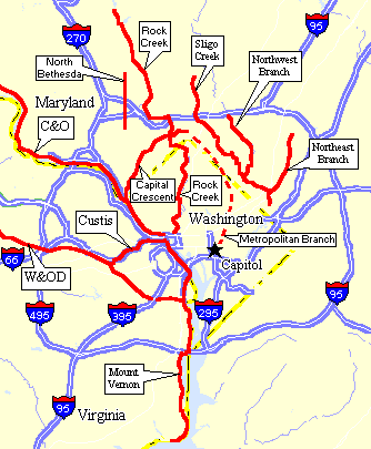
When I crossed Veirs Mill Road there was a detour. Somehow, I ended up near the Twinbrook Metro station in Rockville; very much out of the way. I knew the bus depot at the Metro station would have a good map, and, while I was able to get re-oriented, I realized I had ridden a few miles off my intended route. I don’t know where I got lost but I had certainly discovered the wrong way to Rock Creek.

Even when I finally found the Rock Creek trail, I managed to tilt off to side trails that twice deteriorated into narrow dirt paths. I was glad my first attempt at this trail was on my mountain bike, and not my road bike with its delicate tires.

[As I write this, I Googled “Rock Creek bike trail” and found a website called BikeWashington.org that has a map (HERE) of the portion of the trail that gave me trouble. The very first sentence on that page is, “This section is notorious for getting people lost.” If, indeed, I am an idiot, apparently I’m not the only one!]

Despite my navigational difficulties, I must say that Rock Creek Park is fantastic. (There is an excellent National Park Service map HERE). It is yet another park whose origins lay in the string of fortifications that surrounded Washington DC during the Civil War. While riding the length of the park, from top to bottom, I passed many playgrounds, soccer fields, tennis courts, and picnic areas – all of which were being put to good use. I continue to be amazed at how many people take advantage of the plentiful parks and public recreation facilities in the city. Over and over I passed family barbecues, kids flying kites and playing Frisbee, parents relaxing and reading in camp chairs, and young couples lounging on the grass or along the banks of the creek.

When I could, I enjoyed the scenery, but the ride wasn’t easy. The terrain was undulating, with each restful downhill offset by a short, steep climb. The path followed the course of the creek, so very little of it was straight. Occasionally, I would burst from under the covering trees into the clear – which was good because it gave me a chance to get my bearings, but not good because it exposed me to a 20 mph headwind that happened to be blowing up the Rock Creek valley from the Potomac. I don’t know how you react when faced with a 20 mph headwind while riding your bike. My usual reaction is to yell things that would offend most people.

By the time I reached the bottom (southern end) of the park, I had been in the saddle for 20 miles. I had two half-liter water bottles with me, and stopped at drinking fountains along the way to fill them both several times. Salt caked my cheeks from sweat that had poured from my forehead and dried. I felt great!

Suddenly, the trail joined the road, and the road curved to the left, and I was in front of the Kennedy Center riding along the Potomac River. I stopped to snap two quick photos on this hazy day.

To my right, the river and the Memorial Bridge across to Arlington...

To my left, people using public volleyball nets in the shadow of the Washington Monument (just barely visible in the distance behind the net on the left)...

From there I made a few laps around the National Mall, then went up 7th Street to G Street, where I dropped down the elevator that put me and my bike into the Gallery Place-Chinatown Metro station for the train ride home.

I learned that padded shorts are necessary, even on a mountain bike, if I'm going to ride long distances! (Yesterday turned out to be about 25 miles in the end). I learned I am finally fit enough to dust the cobwebs off my road bike and really put some miles behind me. And I hope I learned the right way to get to the Rock Creek trail next time.

Friday, July 24, 2009

You Name It

I think my car needs a name. I don't know why. It's been ages since I had a car with a name. If you've known me for a long time, you may remember the car I used to call "The Land Yacht." It was a '72 Chrysler Newport that I bought for $300, and it was so big I'm pretty sure you could have landed a helicopter on the roof.

I decided to take a poll of my faithful readers to see what you think. Jennifer suggested the name "McKinley" - after the mountain that fascinates me (and we already have a "Denali" in the family - Kami's dog).

I threw in a couple of ideas of my own. "The Green Monster" is obviously a reference to the left field wall at Fenway Park, and, it seems appropriate because the station wagon is pretty big and, well... green. "The Raft" is a bit of an inside joke that most of you will understand, but also refers to the fact that the car represents my method of "drifting" back to Florida if or when the need arises. "E" is kind of a play on words that reflects the ever-changing nature of things. E-volv...o. Comprende? Verstehen Sie? I know. It's kind of silly, but, then again, I'm kind of silly.

Take a minute to vote on the Official Poll just to the right of this post. Or write a comment or send me an e-mail with your name suggestion, and I'll add it to the poll.

I should forewarn you that the decision will ultimately be made by the Executive Naming Committee which consists of... ME! All decisions are final. I'll have to schedule a meeting with myself before the naming is official. At that point, I will issue a statement to the media, and distribute invitations to the christening ceremony.